 1861 Map of Cooper, Washington County, Maine
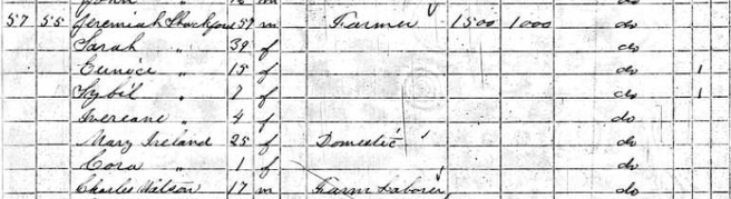
 Based on census records, we know that Jeremiah Shackford, age 57 was living on a farm in Cooper, Washington County, Maine in 1860 with Sarah Shackford , age 39 who we believe was his wife and Eunice, age 15, Sybil, age 7, and Increase, age 4 who we believe to be his children. The census reflects that the real estate value of the farm was $1500 and Jeremiah's personal estate was valued at $100.
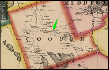
We have found an 1861 map of Washington County which shows the location of individual property owners in 1861 to which we added this green arrow which identifies the specific location of property owned by J. Shackford!
According to this map Jeremiah's closest neighbors were J & D Howe, J W Palmeter, the school, the cemetery, G. Black, and I W Clarke.
We believe that by 1860, Jeremiah's daughter Sarah who was 12 in the 1850 census had married George Washington Black and was living at that neighboring property in 1860 with their son George Washington Black.
We pulled up today's Google maps and believe that J Shackford's property was near the current location of the intersection of Hwy 191 (Cooper Rd) and E, Ridge Road. In the future we're hoping to find property records for Washington County so we can learn how Jeremiah acquired this piece of property which may possibly give us more information about his ancestors.
SOURCES:
1860 United States Federal Census, Washington County, Maine, population schedule, Cooper, page 235, dwelling 57, family 55, Jeremiah Shackford; digital images, Ancestry.com (http://www.ancestry.com : accessed 30 November 2013).
Topographical map of the county of Washington, Maine from Actual Surveys under the Direction of H. F. Walling (New York: Lee and Marsh, 1861); digital image, Library of Congress (http://www.loc.gov/item/2012592371/ : accessed 9 February 2015).
 RSS Feed
